When you receive your NamedLight registration, one of the first things you'll notice is the sky map — a circular image showing a real patch of the night sky, centered on your star. It's one of the details that makes a NamedLight registration feel grounded rather than generic.
That image isn't a stock photo. It isn't an illustration. It's a genuine sky survey image retrieved programmatically using your star's exact astronomical coordinates. Here's how it works.
Where the Image Comes From
Every NamedLight sky map is fetched from the Digitized Sky Survey (DSS), a project run by the Centre de Données astronomiques de Strasbourg — known as CDS — in partnership with major astronomical institutions. The DSS is a digitized archive of photographic sky survey plates taken by ground-based telescopes over several decades. It covers the entire sky and is one of the most comprehensive real-image sky archives available.
The specific survey used is DSS2 color — a composite of three photographic bands (blue, red, and infrared) that produces natural-looking color sky images. The warm golds, deep blues, and cloud-like nebulosity you see in some sky maps aren't artistic choices. They're what the sky actually looks like in that region of space when captured through these photographic plates.
How the Map Is Centered on Your Star
When your registration is processed, NamedLight takes your star's right ascension and declination from the HYG Database and uses them to request an image from the CDS HiPS image service — a system that allows precise image retrieval from sky survey data at any coordinates.
The request specifies your star's exact position as the center of the image, a field of view wide enough to show meaningful context around the star, and an output size optimized for display. The result is an image of the actual sky region surrounding your star — not a simulation, not an approximation, but a real photographic record of that patch of space.
Your star sits at the center. The reticle — the small circle you see in the middle of the map — marks its exact position.
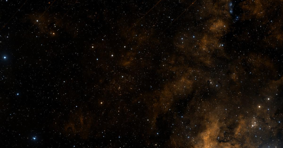
Why Some Sky Maps Look Richer Than Others
Not every patch of sky looks the same, and your sky map reflects that honestly. A star in Sagittarius — near the dense center of the Milky Way — will produce a map teeming with thousands of visible stars and rich nebulosity. A star in a quieter region of sky, away from the galactic plane, might show a sparser field with fewer visible objects.
Neither is better than the other. A sparse field has its own quiet beauty — deep space, a few steady points of light, and your star in the center of it. A rich field shows your star embedded in the dense fabric of the galaxy. Both are real. Both are genuinely yours.
The Same Technology Used by Astronomers
The CDS HiPS service that powers NamedLight's sky maps is the same infrastructure used by professional astronomers and observatories around the world to access sky survey data. It's not a consumer product or a simplified approximation — it's the real thing, accessed through the same interface that researchers use.
When you look at your sky map, you're looking at the same data a professional observatory would pull up if they wanted to examine that region of the sky. That's what it means for a star registration to be backed by real science rather than just nice-looking imagery.
What Happens If the Image Isn't Available
Very occasionally, a network issue or a temporary outage at the CDS service means a sky map can't be fetched at the moment of registration. In those cases, NamedLight uses a fallback image from a pre-fetched library of real sky regions — so your registration always includes a genuine sky photograph, even if it isn't centered on your exact star at that moment. If you're ever unhappy with your sky map for any reason, contact us and we'll sort it out.